US 95 Granite North and Frontage Roads

US 95 Granite North and Frontage Roads
Major Highway Widening Completed Under Budget and Ahead of Schedule
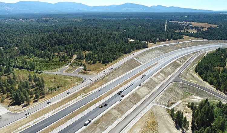
U.S. 95 is the major north-south route in the panhandle of Idaho and the major thoroughfare for commerce. Over the past 15 years, traffic congestion in the corridor has worsened due to population growth and increased freight movement. As part of an ongoing series of improvements to the highway north of Coeur d’Alene, the U.S. 95 Granite North project expanded approximately 2 miles of highway in the Granite area, redesigned more than a dozen intersections and approaches, and consolidated access points.
The Idaho Transportation Department selected HDR to design and develop the segment. By separating low-speed local and residential traffic from the 75 mph highway design speed, the redesigned highway seeks to quell a high crash rate. This segment of roadway had 51 crashes with several serious injuries and three fatalities from 2012 to 2017. The completed project, finished under budget and ahead of schedule, features intersection improvements with acceleration and deceleration lanes and illumination.
Construction was completed one year faster than anticipated and opened to traffic in the fall of 2022. The highway, frontage roads, shared-use path, and approaches improve the level of service and safety within the corridor, and provide multimodal access and connection to the recreational areas of Farragut State Park just 5 miles to the east on Lake Pend Oreille.
Millions in Savings Through Value Engineering
The Granite North project is part of a larger corridor improvements program. The conceptual design included in the Final Environmental Impact Statement for the corridor included relocating the mainline highway and frontage roads east to allow a completely offline construction operation while maintaining traffic on the existing highway. This design would have required three residential relocations, over 2 million cubic yards of earthwork, and a construction cost of over $40 million, exceeding the $23 million available for the project. HDR’s team suggested performing a value engineering analysis to reduce costs, right of way impacts, and residential relocations.
Over 3 months, HDR prepared 15 alternatives that shifted the east and west frontage roads and the northbound and southbound lanes of U.S. 95 onto separate alignments and stair-stepped profiles to optimize earthwork; reduce residential, cultural and wetland impacts; and facilitate ROW acquisition and relocations. As a result of this process, ITD selected an alternative that shifted the corridor to be more aligned with the existing roadway. This reduced ROW acquisition costs by 55% and eliminated two residential relocations. The separated and bifurcated highway alignments also reduced the overall excavation to 1.2 million cubic yards, saving $6 million. Ultimately, the estimated construction cost was cut by $10 million.
Digital Modeling and Drone Surveys
The project design was developed with Bentley OpenRoads to develop a finished-grade digital terrain model used for Automated Machine Guidance. This reduced construction staking and surveying efforts and expedited earthwork operations. The design and model development were critical to understanding earthwork movement in different stages as construction progressed and traffic shifted. Modeling the roadways and considering topsoil stripping, unsuitable material, excavation, and embankment required multiple interim surfaces to confirm construction limits, potential material storage and waste areas, and potential impacts on wetlands and cultural resources.
Along with supplemental cross-section data and survey information, the digital terrain models allowed the use of up to five scrapers, dozers and excavators to strip and grade the project efficiently, with higher-than-normal production rates. Inspectors also used GPS rovers connected to the digital models to check elevations, locations and lengths at any time. This allowed for issues to be caught and worked through with the contractor on the spot.
During construction, routine drone flights captured work progress and assisted with issue resolution and public outreach. The site was mapped during each flight and connected to GPS-enabled portable ground control points to develop accurate site topography after each flight. These electronic surface files were used for many purposes, including issue resolution, revisions to design, and verification/resolution of earthwork quantity disputes. Together with the use of AMG and GPS rover inspections, the close monitoring resulted in a project that was very close to planned quantities with zero earthwork quantity disputes.
Completed a Year Early and Under Budget
The completed highway replaces substandard roadway geometrics and skewed intersections with a new controlled access facility with frontage roads. The winning contractor’s $21 million bid was approximately $9 million below the engineer’s estimate, mainly due to more efficient earthwork and lower asphalt costs. And the completed project came in even less than the contractor’s bid.
The project team relocated utilities, developed several reconfiguration options, and coordinated with multiple agencies and stakeholders to create a corridor that solves immediate needs and integrates with the long-term corridor plans. The project was completed in fall 2022, more than a year earlier than the estimate of November 2023.


