
Benefits of Innovative Stormwater Approach Can Include Lower Costs, Less Effort
Stormwater Management in Oregon
One of the challenges with new development involves changes in hydrology. An increase in impervious area can adversely affect existing streams and wetlands. Systems that were relatively stable — through reliance on processes such as infiltration, evapotranspiration, and flow attenuation through floodplain connectivity and roughness — are abruptly deprived of these processes and experience adverse hydromodification in a short time. These changes introduce additional stresses on wetland and riparian areas and, if not mitigated, increase the potential for erosion and degradation of these natural areas downstream of the development. Additional stresses may arise for downstream drinking water supplies including increased sediment and nutrient load and degradation of water quality including harmful algal blooms that are becoming more prominent in our water supplies.
In Oregon’s Washington County, just west of Portland, HDR has worked with Clean Water Services, a water resources management utility that aims to protect public health while enhancing the natural environment, to meet this challenge in a new way. Standard approaches in many Oregon jurisdictions would provide stormwater detention that matches peak flows for various design storms. This approach meets regulatory requirements for stormwater quantity but provides limited ecological or community benefits. Through the Bethany Creek Enhancement Project (Project), we worked with Clean Water Services (District) to develop an innovative approach that would meet regulatory requirements while enhancing ecologic function, stream health, and quality of life for the new surrounding communities. The Project provided multiple benefits for a variety of stakeholders at a greater return on investment than traditional approaches.
The Project site is located in the western slopes of the Tualatin Mountains within the North Bethany Subarea, which is undergoing rapid urban development. The District was driven by a commitment to protect receiving waters and wetlands from the potential negative impacts of increased stormwater runoff. The project team’s desire was to take an integrated planning approach to attenuate peak flows and incorporate benefits within the landscape, including native vegetation re-establishment, and enhance habitat for birds, aquatic life, and other wildlife.
Based on historic context and similar reference sites, the project site would have likely consisted of a broad valley swale dominated by shrubs and trees before European contact. Beaver likely moved through the reach, creating multiple ponds with emergent and open water habitats. Over the past century, the Project area and surrounding land have principally been used for agricultural production, nursery stock growth, and livestock husbandry. In the last 20 to 30 years, single-family residences dotted the basin landscape. In 2005, the North Bethany subarea was incorporated into the Metro Urban Growth Boundary, allowing for increased density of residential and commercial uses.
The District identified the following Project objectives:
- Achieve net improvement across multiple groups of stream and wetland functions
- Reduce scope and frequency of maintenance activities compared to a traditional regional facility, preferably with actions that would not require future permitting
- Meet the intent of District and County flow attenuation requirements
- Protect downstream reaches from degradation due to hydromodification effects from development
The Project area has been, and will continue to be, responding to land cover and hydrologic changes. As the basin urbanizes, wetlands, creeks, and rivers are subjected to increased flows that contribute to erosion (from peak flows) and lower summer base flows (due to lower groundwater recharge). The Project goal is to impart natural and historic features to the altered creek and wetland system, thereby enhancing the area’s ecosystem functions to increase resiliency, promote stability, and impart natural complexity and diversity to more closely mimic historic characteristics.
The team assessed existing conditions at the beginning of the Project, performed a geomorphic assessment and hydrologic analysis, and collected detailed survey data, including wetland boundaries and topography. This allowed us to establish a baseline condition for comparison after the completion of the Project, as well as to inform what kind of construction efforts would be necessary to achieve the Project’s goal and objectives.
An alternatives analysis followed, with HDR and the District engaging stakeholders including the development community and parks district. Screening analyses compared existing and proposed peak flow rates, wetland functions, downstream erosion, and operations and maintenance costs, the screening process evaluated factors such as shear stresses exerted on the channel bottom and banks, calculated wetland uplift metrics, and anticipated capital and O&M costs. This process considered no action as well as several innovative approaches, including:
- Placement of dense plantings in the channel and floodplain
- Placement of dense plantings and construction of four in-stream flow attenuation features with off-channel features
- Placement of dense plantings and construction of 11 in-stream flow attenuation features
- Placement of dense plantings and construction of 11 in-stream flow attenuation features with increased depth/storage capacity
- Placement of dense plantings and construction of off-channel wetlands with no in-stream flow attenuation
Each alternative, except for “no action,” also included channel improvements and construction of stability features for grade control. Dense plantings and four flow attenuation features with off-channel wetlands was selected as the preferred alternative. The off-channel features in the upland area collect surface water from adjacent development outfalls and convey and detain the flow as it traverses the slope down to the valley bottom. The existing, incised channel would be filled and graded to reflect a plan form that is similar to other reference sites. The chosen alternative also included other, more passive elements such as vegetation, inclusion of downed woody material, and simulated beaver dams. The District has also implemented real-time controls just upstream of the Project area. These actively controlled valves allow for varying the release of flows from stormwater facilities based on pending weather forecasts, providing control of flow rates and therefore reducing stress on the receiving stream and wetland system. The innovative approach supplements the application of real-time controls. Figure 2 provides a rendering, developed before construction began, of the proposed selected alternative with mature vegetation.
During project design, the Project team evaluated ways to configure the flow attenuation features so that no hard building materials would be used (e.g., no concrete structures or prefabricated elements that would not fit with the natural setting). The result was gently graded berms across the floodplain that included flow constricting weirs at the stream channel. The weirs were configured in two different ways to attenuate flows. Two of the weirs are composed of an open-graded rock mix that allows water to slowly pass through the constriction, and the other two feature logs with a v-notch cut in them to constrict the flow. The team worked closely to develop a design that would blend into the landscape seamlessly and look as natural as possible.
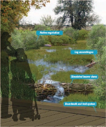
10-15 years of vegetation growth.
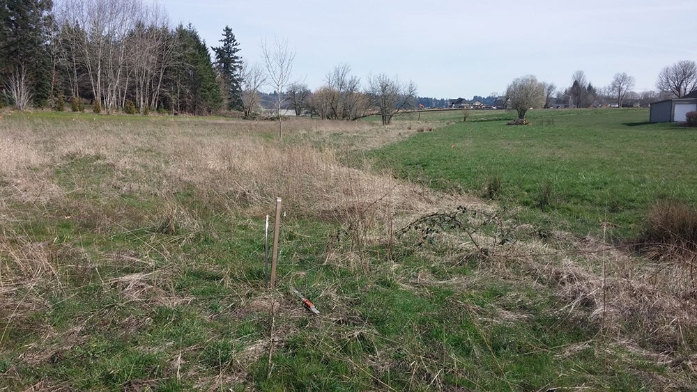
Project construction began in the summer of 2016 and was completed in the fall of 2017. By this time, developments to the south and east had already been constructed, and developments to the north were under construction.
Some minor adjustments to the design to accommodate changing designs for outfall locations were implemented during construction. The District constructed the project with their own crews and provided all of the plantings, including sod mats featuring a blend of native grasses that they grew themselves. By spring of 2018, the vegetation had become well established and the site was beginning to look like the vision developed by the design team.
Since completion of construction, the project site has flourished and the surrounding communities enjoy an amenity that provides a refreshing contrast to roadways, housing, and businesses nearby. The trails that flank the site are being used for recreation and exercise. Water flows across downed logs and through wetlands thriving with native plant species, meandering through the site at a slow pace. Larger storms produce ponded areas that slowly release their volume at a rate that does not erode the stream channel. Trees have yet to mature, but other dense native vegetation provides habitat and flow attenuation.
The Bethany Creek Enhancement Project has improved wetland and stream health at the site, provided flow attenuation for high flows, protected the downstream reach from erosion, and created an aesthetic community amenity that enhances the quality of life in the North Bethany area with lower O&M costs and effort than a traditional stormwater management facility. Combining the innovative approach piloted by the Bethany Creek Enhancement Project with the application of real-time control valves, the District is leading the way in implementing projects that provide multiple benefits to a broad stakeholder community at a greater return on investment than traditional approaches.


