
Experts Talk: How to Adapt Coastal Infrastructure to Protect Communities with Brent Moore
Experts Talk is an interview series with technical leaders from across our transportation program.
Designing Safe, Sustainable and Resilient Seawalls and Coastal Structures
Coastal communities today face an array of challenging conditions, including erosion, flooding and recurring severe weather events, all compounded by ongoing sea level rise. Many areas are investigating the need for new or improved coastal structures, such as seawalls. But creating safe, resilient and context-sensitive structures is a complex task involving hydrodynamic modeling, engineering, environmental and social considerations. The good news is that today’s coastal solutions can offer much more than the imposing hardened structures of decades past. They can be made adaptable and attractive parts of a larger holistic coastal protection network.

Brent Moore, P.E., manages our ports and maritime practice on the Gulf Coast and central region of the United States. Experienced in all aspects of marine projects from planning to design to construction administration, he’s been involved in federal and state seawall projects across the Gulf and East Coasts.
In this interview, Moore addresses planning and design considerations for seawalls in high vehicle and pedestrian traffic areas, how communities can assess risk for future sea level rise and how data management and equity are important components of designing and managing coastal structures.
Q. How are coastal communities today adapting their infrastructure in response to the risks associated with sea level rise? Where does an owner or agency begin?
A. We expect coastal structures to last decades. So during planning and design we must understand where the environment is going long-term. That’s no simple task. It requires a deep understanding of existing local conditions and hazards: Where is the water level of today? What do storm patterns look like? What does storm surge look like? How are the drainage networks laid out and where are they vulnerable?
After an analysis of existing issues, our coastal modeling professionals use sea level rise prediction curves to develop an idea of the future and to determine how flood risks might change over time. These curves look at different scenarios in the coming decades, showing a range of possible outcomes depending on whether median sea level rise is low, high or somewhere in the middle of global predictions. These curves often reveal a dramatic change in flooding frequency, even in intermediate to lower scenarios. For example, current 100-year flooding events may occur every five years by 2100. That increased recurrence will redefine the scope of a 100-year event. It also creates a much bigger risk to any structure, which should guide today’s project decisions.
This upfront analysis of existing local conditions helps owners understand the risks they are taking on, and it informs detailed design and planning. Otherwise communities are kind of shooting in the dark as they design coastal protection for the future.
Equity considerations also play into these decisions. Whenever a community commits to creating infrastructure to protect its valued assets, like seawalls, flood mitigation or avoidance systems, they are making a statement: This area is vital. And if improvements are added or upgraded in one area and not another, it is often clearly stating, or at least implying, which areas are more important. As communities develop seawall programs, addressing equity is key, requiring a clear understanding of the implications of each solution and the message being communicated by the community regarding priorities.
This process starts with public and stakeholder engagement to determine community needs and expectations. This step is especially important in historic, business or residential areas where structures will have a large impact on neighborhood aesthetics or functionality.
Q. In the U.S., where can owners and agencies find resources to respond to the needs of today’s sea level rise threats?
A. In the U.S., the National Oceanic and Atmospheric Association puts together a document called Global and Regional Sea Level Rise Scenarios for the United States every couple of years. It’s a multi-agency, multi-university research initiative, backed up by sound science and policies.
Our coastal modeling experts use that regional information and apply it to local communities to help our coastal structures team. These coastal experts provide planning services, numerical modeling, analysis and oceanographic studies. We provide water level estimates and wave loads to designers performing detailed structural design.

Q. How are new engineering solutions and design trends in coastal infrastructure addressing future uncertainties?
A. Owners of seawalls and coastal structures are putting a strong emphasis on sustainability and resiliency. They incorporate more resilient project components like pervious pavements to allow increased storage and more rapid dissipation of floodwaters.
For those areas where a hardened structure is needed, there are methods and approaches being implemented that can increase the service life of the structure for the long term. With concrete structures, for example, new concrete mixes, purposeful connection detailing, crack control design, specific construction finishing requirements, and coatings can provide a 75-year to 100-year lifespan for marine waterfront structures. When possible, projects are also incorporating design elements that don’t require or rely upon maintenance and periodic upkeep, which is often not performed long term or lapses over time.
An experienced and forward-thinking design team can also create facility adaptability that meets current needs but allows for future additions. For example, designing a seawall’s foundation today for a much higher anticipated load in the future as sea levels rise can accommodate a project’s near term budget constraints, while allowing enhancements to be implemented with little additional relative cost in the future. Our design team used this approach on the Port Everglades Slip 1 Expansion in Fort Lauderdale, Florida. The new bulkhead seawall will be raised 2 feet higher than its current height, but it has been designed with the ability to add another 4 feet in the future. A benefit-cost analysis showed the dramatic difference in cost between preparing for that rise now and putting off changes until later.
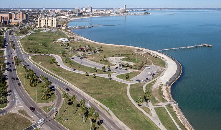
A similar approach was used on the seawall renovation project in Corpus Christi, Texas.
Q. How can seawalls and coastal flooding solutions be designed so they don’t become a blight, particularly in areas such as high tourism areas where aesthetics are key?
A. Where there’s a high interest in aesthetics, engineering solutions are blended with landscape architectural solutions. The holistic seawall solution could include and incorporate a series of raised walls, planter boxes, benches and seating areas to provide additional flood protection.
Landscape architects may also work with coastal designers to create a living shoreline approach with natural materials or a grass-covered earthen berm where appropriate. These soft structures prevent overtopping and erosion but use natural materials such as integrated topography, holding ponds and natural rock-faced retaining walls.
Even these soft structures can be designed with future adaptability in mind, so elevation can be added if needed. As long as the foundation is designed to handle extra weight and increased flood depth and surge, adding more height in the future when needed can often be done cost effectively.
Improving or extending existing seawalls sometimes prompts another aesthetic considerations. As these are often historic structures, it’s important for many communities to maintain their look by using the same type of materials, whether rock, stone or timber. Our challenge as designers is to add strength and resiliency with modern techniques while maintaining the look of structures constructed 100 years ago or more.
Q. As seawalls and new infrastructure are built, how can owners/agencies better manage their assets for long term, sustainable protection?
A. Many seawall projects or programs begin with surveying and data acquisition. While this data is key to determining the specifics of a project area and critical to design, it as well as the designed system can also be leveraged for future asset management. This digital data can be incorporated into GIS databases, expanded upon over time and used to track the condition and specifics of these seawall systems.
Having and successfully implementing a master plan for future development is also important. As components are added to, or taken away from the system, modifications and adjustments can be accounted for. These types of adjustments often affect the volume of flooding, and in turn, the ability of the seawall system to protect the area from flooding.
For owners that want to consider this, it’s important to add the design criteria and assumptions to the basis of design document at the beginning of a project and to continue updating the living document throughout the life cycle of the project. By thinking about and planning for this capability as part of the overall strategy from the beginning, it can be used as a valuable tool in the future to manage the entire system. And it in turn aids in the flexibility of the project to deal with changing water levels. With accurate design data, analyses, record drawing and specification information and the like, adding new features or modifying structures in coming decades will be much easier, potentially without repeated or added studies.
Collecting the right data at the beginning also eases the process of updating site-specific coastal models. The most labor-intensive part of creating a model is at the beginning, when determining the right model grids, boundary conditions and more that drive the numerical model. Once the model is developed, however, it’s a much smaller task to adapt it to changes in the environment or in reference guides. This can be a very powerful tool to help communities continue to assess their risk from sea level rise and ensure they’re responding appropriately.
Q. How did your career lead you to this specialty?
A. I grew up land locked in a rural farming community in northeast Texas. After earning a degree in civil engineering with a focused structural and geotechnical curriculum, I migrated to the Gulf coast and found a job in the maritime world that matched my engineering skills and interests. From there, water quickly became a primary focus (both business and recreational) and over the last few decades, I’ve been involved with a large variety of marine-related engineering challenges. The area where the land meets the sea is a unique, challenging environment which requires a special blend of engineering skills. I’m blessed to have been able to work with communities and owners of marine structures all over the world.
Each Experts Talk interview illuminates a different aspect of transportation infrastructure planning, design and delivery. Check back regularly to discover new insights from the specialized experts and thought leaders behind our award-winning, full service consulting practice


