
Re-Plumbing California
Preparing for Water Management Under Future Climate Conditions
The California water capture, storage and delivery infrastructure system is quite possibly the most extensive in the world. It can capture rainfall at the northern border of the state, store it and then move it over 750 miles to the southernmost portion of the state along the Mexican border.
Drought and hydrologic variability is a way of life in California, as the state’s climate and hydrology are unlike any other in the nation. With dry summers and wet winters, the state’s climate is characterized by dramatic variability and uncertainty. Climatic conditions range from temperate rainforest conditions in the north to arid deserts in the south with precipitation varying from year to year, anywhere from extensive droughts in one year to damaging floods in the next. There simply is no such thing as an average water year in California hydrology, which makes managing water in this state particularly challenging.
Adding to this complexity is a water management system originally conceived in 1919 that centered on capturing snowmelt in the state’s vast mountain ranges and slowly releasing that stored meltwater to provide a year-round supply of water to areas that would not otherwise receive significant rainfall from May to November.
Be the first to know
Subscribe to receive our Water Insights
Stress on the Water System
With the growth of California’s population from 5.7 million in 1930 to 39.5 million in 2020, the state’s water infrastructure backbone has begun to show its age and design limitations. Further stressing the system are the myriad of environmental laws that original designers did not have to consider. These include national regulations such as the federal Endangered Species Act, Clean Water Act and National Environmental Policy Act, as well as those unique to the state including the California Endangered Species Act, Porter-Cologne Water Quality Control Act and California Water Law. More recently, changing climate and rainfall patterns have become a challenge for water managers to address, plan for and incorporate into this already overly complex system.
At HDR, we are playing a major role in addressing all of these challenges by supporting the Sites Project Authority in the planning, design, construction and environmental permitting of the new, 1.5 million acre-foot Sites Reservoir — the first major Northern California reservoir to be built since 1978 and the first major new water right in over half a century. Our primary task is to recommend, establish and execute solutions that will allow the Authority to construct and operate this project within the anticipated time frame and estimated budget, with minimal risk and approval by all oversight agencies. Our new Lakes and Reservoirs national practice group maintains key roles on this effort, pulling from members’ diverse expertise in water quality, limnology, reservoir management, environmental permitting and ecology to provide the Authority with advice and information as part of the daily decision-making activities in the development of the project.
California’s Plumbing
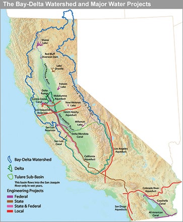
Out of more than 1,400 reservoirs in the state, 42 dams and reservoirs and 1,500-plus miles of major canals, tunnels and related facilities make up the backbone of the system. This key infrastructure comprises the State Water Project, which is operated by the California Department of Water Resources, and the Central Valley Project, which is run by the U.S. Bureau of Reclamation. These two projects alone provide drinking water for more than 30 million people, support 5.75 million acres of farmland and sustain the sixth-largest economy in the world, all while maintaining vast native ecosystems including the largest freshwater tidal estuary in western North America and four runs of salmon.
A Changing Climate and Water Management Paradigm
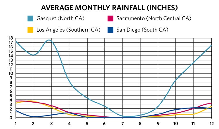
California’s water infrastructure is designed to capture precipitation during the state’s rainy season and store it for use throughout the year. Although 60% of the state’s population lives in semi-arid Southern California, most of the precipitation falls in the north and east-central portion of the state from December through March (Figure 2). Up to one-third of this precipitation falls in the Sierra Nevada Mountains in the form of snow. By accumulating snow during the wet winters and releasing it slowly during the dry springs and summers, the snowpack acts like a giant reservoir that is essential in meeting the state’s municipal, industrial, agricultural and ecological water demands.
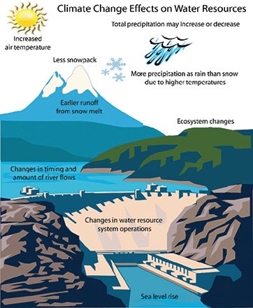
Climate models predict more variable weather patterns throughout California. More variability can lead to longer and more severe droughts and floods, which present significant challenges to California’s water supply. These models also predict more precipitation to fall as rain and not snow, breaking the current water management paradigm in the state. As a result of this change in the form of precipitation, the peak discharge from melt will be up to three months sooner, moving it from April into February. Perhaps the most challenging prediction is that rising sea levels will bring more saltwater into the Sacramento-San Joaquin Delta — the heart of the California water supply system and a key source of water for 25 million people and millions of acres of farmland. To keep the salt water out, more freshwater will need to be pushed through the Delta, decreasing the amount of water available for people who have historically relied on it.
Add in increasing frequency of extreme and exceptional droughts, catastrophic wildfires, declining groundwater reserves, the continued decline of endangered salmon, a collapsing Delta ecosystem and continuing population growth, and it becomes clear that California is facing unprecedented challenges to a water management system that was designed for different conditions.
A New ‘Old’ Project Emerges
Beginning in 1955, DWR and BOR initiated the evaluation of expanded surface water storage in the Sacramento and San Joaquin Valleys; Sites Reservoir was part of that evaluation. In 2010, a new entity, the Sites Project Authority was formed to pursue the development and construction of the Sites Reservoir Project, which since 1955 has been viewed as an ideal location for additional off-stream storage to provide direct and real benefits to instream flows, the Delta ecosystem and California water supply. Sites Reservoir would not rely on snowmelt, instead it would capture winter runoff below the existing reservoirs in the Sacramento Valley. Because of this, it’s a new source of water that will inherently adapt to future conditions. It will be operated to improve water supply resilience to the predicted changes in weather. Much of the rainfall from extreme events — especially those that occur back-to-back when the ground is saturated — runs off before it can be captured by the State Water Project and Central Valley Project for maximum environmental, urban and agricultural benefit. By capturing a portion of these high-flow events from the Sacramento River and operating in conjunction with other CVP and SWP reservoirs, Sites Reservoir would increase the resiliency of water supplies by not relying on spring snowmelt for filling and instead capturing winter storm-related runoff that is not normally captured. Unlike most major reservoirs in the state, Sites Reservoir would not block a major stream or river. It would be located 17 miles west of the Sacramento River and, in critically dry water years, will on average provide an additional 250,000 to 300,000 acre-feet of water to improve water quality conditions, help critically endangered salmon and meet urban and agricultural demand.
Playing Our Part to Support California’s Water Future
Since 2018, we have been supporting the Authority by acting as staff support, program managers, project managers, scientists, engineers, water operations specialists and environmental permitting specialists. A key part of this effort has been supporting the Authority’s environmental permitting and planning manager by managing the day-to-day activities of the extensive state and federal environmental permitting for the construction and operation of the new reservoir. With over 20 permits required, this is a challenging task in highly progressive California, where a single environmental permitting document commonly exceeds a thousand pages and litigation threat looms over even some of the most mundane projects. The state itself has grown to be a leader in environmental protection and regulation, pioneering some of the toughest state legislation to address environmental issues such as climate change, toxic waste disposal, water quality, pollution and loss of wildlife and habitat.
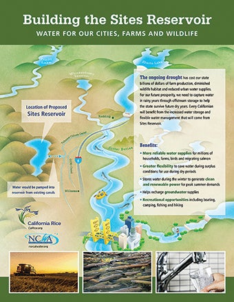
The Sites Reservoir project will inundate over 13,000 acres of grasslands, wetlands, streams, oak woodlands and farmland, much of which is suitable habitat for rare vegetation communities and threatened and endangered species. The project will also file for a water right to pump and store up to 1.5 million acre-feet (488.8 billion gallons) of water from the Sacramento River a year. The river is home to numerous threatened and endangered species and rare habitats and supports urban, municipal and industrial water demands, as well as large recreational and commercial salmon fishing. Given all of this, if you wanted an environmental permitting challenge in California, this project would be at the top of the list. Below are a few key components and lessons learned of this ongoing permitting program.
California Environmental Quality Act and National Environmental Policy Act
The primary state and federal environmental permitting documents are those associated with the California Environmental Quality Act and the National Environmental Policy Act in that in that they are designed to provide the public with a disclosure of a project’s environmental effects across over a dozen different categories, from cultural and tribal resources to water quality, climate change, environmental justice, fisheries, energy and agricultural resources.
Acting as staff to the Authority's environmental permitting and planning manager, our permitting and planning program managers and technical experts worked to oversee the preparation of the California Environmental Quality Act and the National Environmental Policy Act permitting documents by numerous consultants. This process transitioned through two state governors and three presidential administrations, each with differing environmental and water policy platforms to adapt to and address. Key to this process was to confirm that the Authority’s EPP manager and executive director had the necessary information and support to brief the Authority’s board of directors and numerous environmental committees and discuss the options, opportunities and risks of the CEQA/NEPA analysis and approach with them. All 23 member agencies or entities that make up and fund the Authority have concerns and objectives that are specific to their particular location within the state (north to south and east to west), constituency, rate payers or, in some cases, their own family farms. Addressing each of the member’s questions and concerns while balancing the overall project objectives requires effort, organization and flexibility, which we provided to the Authority staff through the management of the 100-plus person consultant team.
Working with the Authority’s design, geotechnical, modeling and environmental consultants, we organized and led interagency meetings between state and federal permitting agencies. We also worked extensively with the project’s federal partner, BOR, to mesh the complexities of different state CEQA and federal NEPA documentation and analysis requirements into a consolidated Environmental Impact Statement/Environmental Impact Report for the project. The result of this effort was the successful release of the Draft EIR in November 2021 for public review and comment.
Federal and State Endangered Species Act
Like the federal government, the State of California has its own Endangered Species Act statute. However, unlike the federal ESA, which only requires an applicant to minimize and mitigate the impacts of take of a listed species to the “maximum extent practicable,” CESA requires that take must be “fully mitigated” (e.g., a minimum of one-for-one mitigation) and must not jeopardize the continued existence of the species, which is a quite higher standard when compared to federal regulations.
The Sites Reservoir project has the potential to affect 13 federally listed species and nine state-listed species, including both terrestrial species like the giant garter snake and Swainson’s hawk and aquatic species such as Chinook salmon, green sturgeon and Delta smelt. Members from our lakes and reservoirs practice group acted as technical support staff to the Authority’s EPP manager and directed the on-the ground daily activities of the state and federal ESA permitting of the project, providing the Authority’s EPP manager the flexibility to choose which activities to take a lead role in while still maintaining the overall program and addressing the concerns of the Authority’s board of directors and numerous environmental committees.
We worked with the Authority’s environmental and modeling consultant teams to develop and refine terrestrial and aquatic habitat models for state and federally listed species and wetlands that were used to identify potentially suitable habitat for these species throughout the more than 20,000-acre project area. One of the strategies we employed was to negotiate with the California Department of Fish and Wildlife and U.S. Fish and Wildlife Service to allow effects, determinations and mitigation ratios in the ESA permits that were modifiable. Knowing that the project would initially grossly overestimate effects due to the lack of access to biological surveys of 99% of the project area, we confirmed that the project’s mitigation requirements and financial assurances would be reduced as appropriate biological surveys were performed and effects to listed species and rare habitat were verified. If no species or habitat were found in previously unsurveyed areas, the mitigation and associated financial assurances would be reduced without the need for a lengthy permit amendment. This addressed some key concerns by the Authority and its members about over-mitigating for the effects of the project.
We also worked as part of the hydrological modeling and fisheries teams to assess the aquatic effects of the construction and operation of the project on listed aquatic species within the Sacramento, Feather and American Rivers, as well as the Delta. These effects ranged from near-field effects that would occur at the Sacramento River diversion pumps, to farfield effects seen over a week’s water travel time and 150 miles downstream from the project’s diversions. We then planned and moderated more than 60 workshops and technical meetings with state and federal scientists and regulators in a 24-month period to develop suitable aquatic effects models and water diversion criteria that would meet regulatory requirements while achieving the goals of a permittable and affordable project. Although this is a highly collaborative process, not all areas of concern are consistent across agencies and their respective management, staff and scientists. We worked to address this issue by supporting the Authority in preparing for and facilitating dialogue among state and federal agencies and between their staff and scientists and the Authority’s subject area experts and technical consulting team. We employed new and developing science from local California river systems in our discussions that allowed the regulatory agencies to reduce their required Sacramento River bypass flow criteria from 13,000 cubic feet per second year-round to 10,700 cfs during the peak salmonid outmigration period. This results in a substantial increase in the amount of divertible flow for the project while simultaneously protecting listed salmon. ESA permit applications continue to be refined, with the first permit application being submitted in the Fall of 2023.
The Work Continues
We continue to support the Authority in obtaining a water right and permits under the Clean Water Act, state and federal Endangered Species Acts, National Historic Preservation Act, Bald and Golden Eagle Protection Act, California Streambed Alteration Agreements, and the other dozen or so key permits that would allow construction and operation of the project. Our goal is simply to support the Authority and its consultants in achieving the goals and objectives of the $4 billion project. Our work extends beyond the several key insights and lessons learned described above as final CEQA/NEPA documents and permits need to be obtained and the terms and conditions implemented. The project also has a several-hundred-million- dollar mitigation and adaptive management program to implement, which we will support. To do so, we will continue to look for ways to expeditiously carry out the program oversight, technical review and daily support tasks that move the project from the current planning and permitting phase into construction and ultimately operation.
Questions?
Contact John.Spranza [at] hdrinc.com (John Spranza) or at +1 (916) 679-8858 for more information.


