
Alaska Earthquake Emergency Response Shows the Power of Technology and Collaboration
An Inventive App Combines Data, Visual Information and Geographic Location to Streamline Response
By Mike Davis, Senior GIS Programmer
A magnitude-7.1 earthquake shook south-central Alaska November 30, 2018. The earthquake and subsequent aftershocks damaged roadway facilities as well as other essential infrastructure throughout the region. As the snow melted and the ground started to thaw the following spring, the Alaska DOT&PF had a daunting task ahead of it: identify and repair the extensive damage to major infrastructure including bridges, walls, roadways and facilities.
Making this more complex was Alaska’s short construction season, which meant that many inspectors from several contractors would have to perform the work in a short amount of time, so that repairs could begin quickly. The goal is to complete the majority of permanent repairs in two construction seasons, prioritizing the most critical sites.
HDR was engaged to manage the $70 million program and lead a team of consultants in identifying, facilitating and monitoring repairs to earthquake damaged sites throughout south-central Alaska. At the beginning of the process this meant combing through stacks of paper reports and photos that had to be reviewed and analyzed in order to prioritize repairs and group sites into projects. Our team knew there was a better approach, and soon engineers and application developers were working on a custom-built app to save precious time needed for repair work.
The Result: Quake Inspector App, a One-Stop Shop
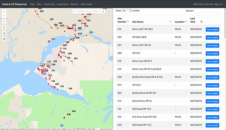
Our team of geospatial professionals, working with project leaders, created a new application to serve as a one-stop shop for all the information that would have otherwise been contained in multiple paper reports. With the press of a button, project leaders, contractors and Alaska DOT&PF leadership can efficiently review information about any given site, including previous reports and photos; it’s a tool available for the entire team.
“This app enhanced our ability to respond quickly and allowed everyone to do their jobs much more efficiently,” HDR project manager Kristen Keifer said. “I can’t overstate how indispensable this app became to the project.”
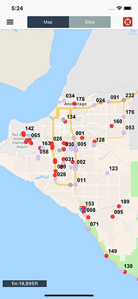
Called Quake Inspector, the custom designed mobile app for iOS was created with the EsriArcGIS Runtime SDK and facilitates the collection of inspection and monitoring records as well as site photos. Based on a model more commonly used for large construction projects, the app allows inspectors to fill out their report, upload pictures and compare it to previous reports. The information is immediately available for review and analysis in the web portal. People from several entities, including our subcontractors, and the Alaska DOT&PF, can all use this streamlined system to enter and access information. That continuity was especially important because a core team of inspectors was supplemented at various points – making it simpler to ensure consistency across reports that would have been filed on paper.
The app and web portal especially proved its worth in late summer 2019. Many of the sites that were repaired in the middle of winter under unfavorable construction conditions showed signs of degradation, presenting a potential safety risk to the public and maintenance and operations crews that would soon be maintaining and plowing the roadways. Using the inspector’s notes and photos within the app, we were able to show Alaska DOT&PF the changing conditions at the sites over time. As a result, seven sites were fast-tracked to construction and repaired before the next winter season. “It was a true testament to the power of having the right information available to put in front of the right people at a critical time,” said Keifer.
Tracking Budgets and Engaging the Public
To date, more than 250 damage sites have been inspected with nearly 5,000 photos collected among them. What would have been thousands of physical pages of inspection reports are now one comprehensive, easy to search database system that can be accessed via any computer or mobile device. Photos and inspection reports generated on paper prior to the availability of the app were also integrated into the bases, which aided in the transition and consistency from the time of the event to the present.
In addition, project financial data can be integrated with data from the app. This makes it much easier to see what has been spent and what has been allocated, a requirement for federal emergency funding. Alaska DOT&PF can pull up any site and see exactly how much has been spent and where that money has been allocated. Additionally, the app has also been modified for use at transportation fairs and other public engagement events to effectively inform community members and stakeholders on the status of local projects.
“Every project presents a new opportunity to inspire ingenuity and to partner with our clients in developing tailored solutions and new innovative tools that enhance design and program delivery,” said Highways and Roadways Director Bernie Arseneau. “In this case, Quake Inspector helped the emergency response team streamline project organization and scheduling to advance emergency repairs on critical infrastructure.”
Pushing Our Technology Practice Forward
The same methodology and technology can be applied to a wide range of real-world applications once you understand the unique needs of each project. The Quake Inspector app and web portal was created based on our experience fielding apps and dashboards for more than 45 client and company projects. Since the start of this project, we have taken the lessons learned and applied them to construction monitoring and right-of-way management projects in South Carolina, Utah and Colorado.
Our developers continue to build upon previous efforts, customizing and optimizing a core code base with each new project. We constantly strive to use technology to create new efficiencies for our clients.
About the Author

Mike Davis is the mobile technology practice group lead for our geospatial and information management practice. Mike was born and raised in Alaska and is based in Anchorage, where he focuses on mobile app development and promoting the use of technology solutions to improve project workflows.
