

Experts Talk: BIM and 3D Design in the Field with Alexa Mitchell
Experts Talk is an interview series with technical leaders from across our transportation program.
Transition From Plan Sheets to Models Continues to Drive New Opportunities but Still Requires Strategic Thinking by Transportation Owners
Building information modeling (BIM) is fundamentally changing the way transportation projects are delivered. 3D models are replacing plan sheets, and some states are even exploring their use as the new legal documents used for design and construction. While this creates new opportunities for accuracy and collaboration, the shift away from plan sheets is also disrupting processes that field staff use today.
Alexa Mitchell, our transportation BIM program manager, has a background in national-level research and regional implementation, helping transportation leaders across the United States deliver projects more effectively through BIM technology. In this interview, she discusses the benefits of 3D models, explains what agencies need to know as they increase their use of BIM and addresses the challenges field staff face when adapting to 3D models.
Q. How does the transition to 3D deliverables affect the way field staff such as contractors and construction inspectors operate?
A. We’re a few years into the industry’s transition from paper plan sets to digital tools. Today, contractors and inspectors are much more familiar with model-based workflows. But this adjustment remains a primary concern for many people. Staff that were used to relying on plan sheets for information about what they’re constructing are now learning new methods for determining correct measurements, dimensions, quantities and more. As I speak to field staff and others across the country, my message is similar: Your job is not changing; you still must do the same things you used to do. But the tools you use are changing, and those new tools can provide additional information and benefits not previously available.
New skills are needed to use these tools to access information. Specifically, instead of printed sheets, designs are accessed via a tablet or computer. Usually in the field, it will be a mobile device of some sort, with an app used to extract needed information from 2D and 3D models. That information can include locations and elevations, notes, dimensions and pay item quantities. Because these models are tied to GPS locations, GIS mobile apps can also be used to create customized perspectives, allowing workers to see plans from their own location on the project site when desired.
In my experience, the most successful programs focus on providing information in a format that matches how people actually work in the field. Many apps and views of models within apps are customizable. If there is a particular view that would make work easier — for example, recreating a similar look to familiar flat sheets — expressing a preference to designers ahead of time can help make that happen.
Q. What do these new models and apps look like for those in the field?
A. The tools available today are far more mature than they were when agencies began piloting digital delivery a few years ago. Instead of traditional plan sheets and cross sections, for example, digital plans provide a combination of 2D and 3D information.
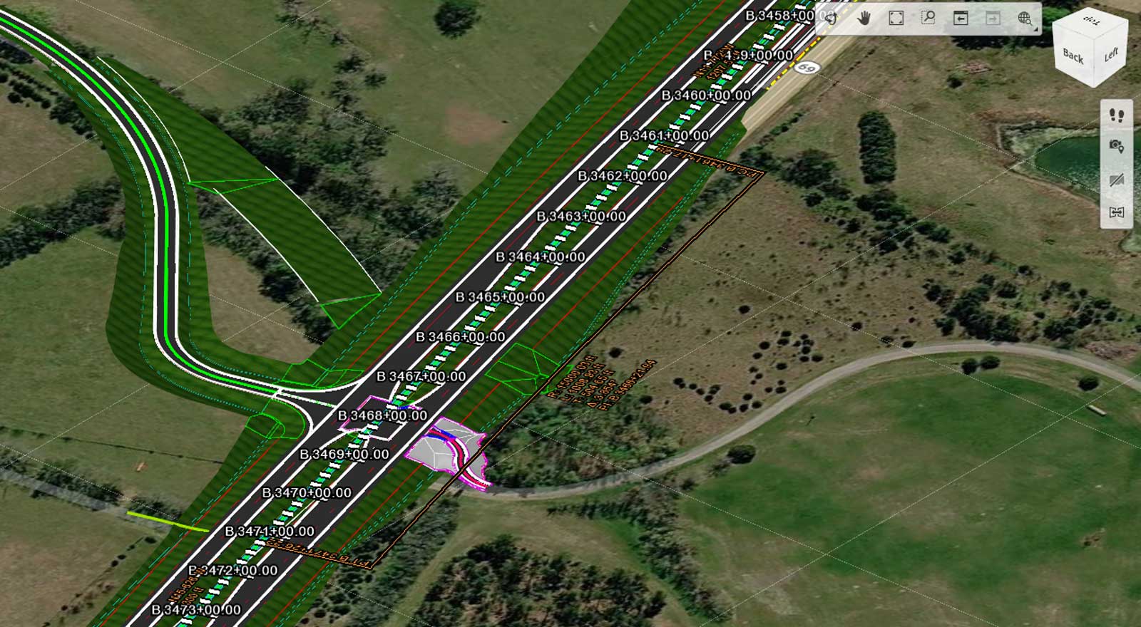
The information is similar to what has traditionally been displayed on plan sheets, with line work as well as notes, callouts and stationing. But users can zoom in and out and navigate the entire project using this view. You can also turn layers on and off to focus on specific aspects of the project or declutter the view.
One easy way to think about it is to imagine these 2D digital deliverables as a long giant PDF roll-plot — but instead of paper you view it with a tablet and a viewer app.
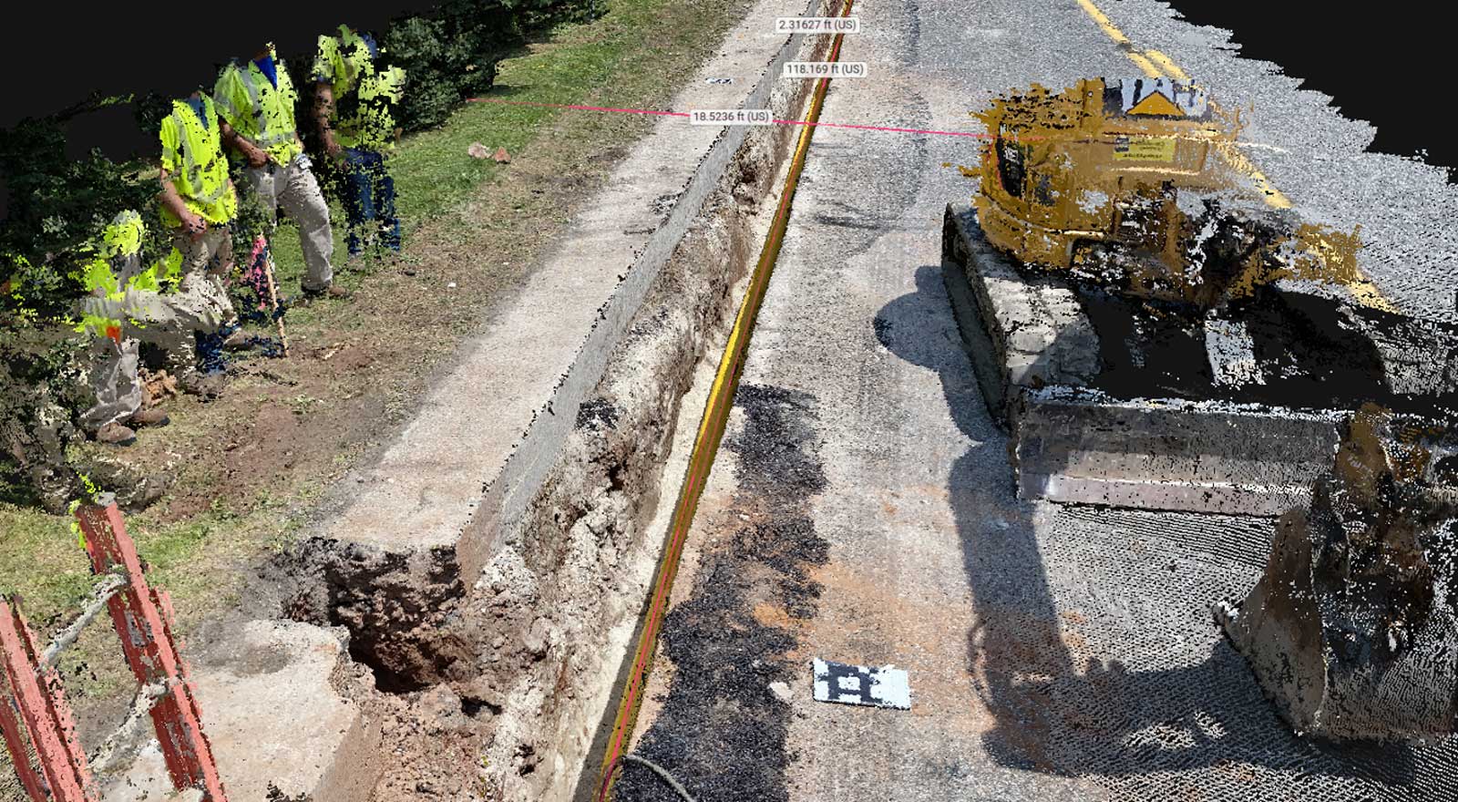
A key difference is that it is now possible to view the design in a 3D environment. These 3D models contain the information commonly found in plan, profile and cross section sheets. Examples include stations, elevations, dimensions and parameters and pay item information. The 3D model elements can also have files attached, such as PDFs of the corresponding standard drawings, spreadsheets with calculations, etc.
Q. What's the benefit of 3D models for owners and those in the field?
A. 3D images communicate design intent much better than 2D representation that requires multiple pages to show an entire project. Even those with lots of experience still miss things when piecing together different sheets like a puzzle. Beyond that visualization aspect, there are clear benefits to different members of the project team:
— Owners of the assets get a database of information faster and at less expense — and sometimes this is information they wouldn’t have otherwise. For example, several years ago, there was a problem across the United States with a specific guardrail end terminal. People needed to know where those terminals were located. But in most cases, nobody knew exactly which guardrails they had. So, owners sent people to drive up and down their roadways, trying to figure out where these devices were located. If they had databases with the exact locations of those assets, that would have cut out days or weeks of field verification.
A 3D version of assets, including what they look like in their location, can serve as a container that houses detailed information like the manufacturer, installation date and any repairs — all information needed to upgrade infrastructure. Our team provided this kind of as-built database on the Gov. Mario M. Cuomo Bridge project, giving the owner a virtual model that included information on each part and its status.
— Contractors also benefit from virtually seeing the project before it is built. This can save considerable time. Contractors can use the 3D deliverables to pose questions and get information from people more quickly. With everybody looking at the same model, there's less confusion. Because of their cloud-based nature, many of today's platforms also allow markups and collaboration between designers, contractors and owners. That means members of project teams can review the same information without needing advanced CAD expertise. Overall, we're observing that they save time in the field, and that makes accelerated timelines more feasible.
Contractors can also use 3D models, depending on the level of detail, for safety reviews. And they can use a model for understanding what materials they need to order. Contractors can connect these models to their schedule and the materials needed at certain milestones, to virtually see a sequence of events. So, for the contractor, it's great for estimating purposes.
— For construction inspectors, a 3D model often means easier documentation of what they see in the field. While undertaking their inspection, they can use the virtual environment to pinpoint the as-built asset they are verifying and compare it to the model. Then they can export that information as validated to a separate database, freeing them from manually re-entering information about their observations. Rather than filling in forms and creating sketches, they can use the model’s virtual environment to streamline their documentation.
Q. How does a transition to 3D deliverables and the needs of those in the field affect designers and others earlier in the project process?
A. Part of the challenge right now is that the standards for what to include in a model are still developing. That puts the onus on designers to create models that fit what those in the field need.
We worked with the Utah Department of Transportation (UDOT), for example, on some of their 3D modeling pilot programs. One of the major areas of feedback from contractors on those pilots was a lack of consistency in the models. Contractors knew that all the information would be in the model, but where that information was, how it was presented, how it could be accessed, was different depending on the designer.
Partly as a result of feedback like this, UDOT hired HDR to help them create the nation’s first model development standards manual. It lays out specifics on what needs to be included and what should be left out of a design. For example, do designers need to model topsoil or not? There isn’t a wrong answer, as long as the contractor knows consistently one way or the other. If it’s left out of the calculation, contractors will need to know that and account for it in their estimates and construction plans.
Developing those standards during model development is key to improving accessibility and ease of use for those in the field that use the model. If they can count on it looking the same every time, with a consistent method for finding the information they need, it will be much easier to adapt to a new process.
New standards are also being developed to improve software interoperability. Contractors often work with multiple design firms or clients using different platforms. Open standards that make information easier to exchange and use across platforms will improve access but also require significant coordination. This is something that I’m increasingly passionate about. In fact, I sit on the buildingSMART International Infrastructure Domains Steering Committee, which is helping guide the industry towards that common approach.
Q. What needs of field staff should be considered as agencies transition to 3D models instead of plan sheets?
A. It’s not just buying software. You must think about all the components. Technology can easily become the focus in discussions about the transition, but it is often the other parts that are more difficult.
When you know you want to deploy BIM, you need to know the entire scope of what will be required. That begins by developing a plan that addresses your specific needs, looking at not only the technological tools but also the human component. How are you going to bring people along who have been doing things the same way for 20 years? How do you transition DBEs and smaller firms? What does the stakeholder communication plan look like? All of that is part of a wider strategy that needs to be developed.
HDR helped the Pennsylvania Department of Transportation with this transition using a “crawl, walk, run” approach, taking on activities that have lower barriers to entry to achieve small but rapid success, setting the agency up for more complex tasks. By 2025, they were able to set things up where all the projects could be bid using 3D technology. That was their goal, and they met it. Now they have over 80 pilot projects in different stages of design and construction.
Pilot projects have proven extremely helpful for improving processes, especially for agencies that are exploring the possibility of making the 3D model the legal design document. HDR has assisted with many of these early 3D deliverable pilots in the U.S., and in many cases, adjusting to a new process can be more difficult than simply learning a new tool. If the tool is intuitive and is the right tool, it could just take a day or two of training before it can be used. But new processes and navigating a new medium often take more time to get used to for staff. Completing a pilot project and seeing the tools in action, like PennDOT did, along with learning from any mistakes made, are often necessary to help staff become comfortable.
Q. As BIM adoption increases and digital delivery programs mature, what comes next?
A. I see the industry focusing on the information contained within models and how that information moves from designers to contractors, inspectors and owners.
Current efforts around open standards, information management and data exchange are helping reduce dependence on proprietary workflows and making it easier for project teams to collaborate. We're also seeing growing interest in how model-based information can support asset management, digital twins and future AI-enabled applications.
The common thread is that the value extends beyond creating the model. The goal is to create reliable information that continues delivering value long after design and construction are complete.
Inspiration & Advice
Q. How did you become involved in BIM and 3D design?
A. It was nearly 20 years ago during my tenure with the Missouri DOT. I was asked to work with regional contractors on finding a solution for delivering 3D models they could use with their GPS-guided earthwork equipment. I’ve been working on advancing the practice ever since, and I have met incredibly smart people along the way that have taught me so much!
Q. What advice do you have for those just beginning to encounter 3D design in their career?
A. It’s an exciting time to get started. The tools are getting better, and we have learned so much. Definitely, look for ways to learn and collaborate with your peers, and don’t be afraid to try new ways of doing things.
Each Experts Talk interview illuminates a different aspect of transportation infrastructure planning, design and delivery. Check back regularly to see new insights from the specialized experts and thought leaders behind our award-winning, full service consulting practice.
